
General information
India is located in the Northern Hemisphere between 8°4-37°6 north latitude and 68°7-97°25 east longitude. The latitudinal extent of entire India is between 6°4 – 37°6 north latitude. The area of India is 32 lakh 87 thousand 263 square km. India is the 7th largest country in the world in terms of area, while it is the 2nd largest country in the world in terms of population. In terms of area, there are six countries larger than India – Russia, Canada, China, United States of America, Brazil and Australia. (8th largest country Argentina) India’s area is 2.42% of the entire world’s area, while Its population is 17.5% of the total world population. (According to 2011 census) There are 8 big countries of the world in terms of population – China, India, etc. RA, Indonesia, Brazil, Pakistan, Bangladesh and Russia. India’s extension from north to south is 3,214 km. And its extension from east to west is 2,933 km. Is. The length of India’s land border is 15,200 km. The length of its coastal part is 7516.6 km. Is; But the length of the coastal part of the mainland is 6100 km.
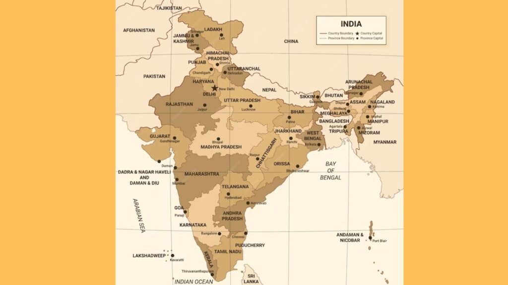
There are 7 countries adjacent to India’s territorial waters/sea borders – Pakistan 2. Maldives 3. Sri Lanka 4. Bangladesh 5. Myanmar 6. Thailand 7. Indonesia.
Countries bordering India’s land and water borders are Bangladesh, Myanmar and Pakistan. The southernmost point of India is Indira Point. It is located in Greater Nicobar Island. Earlier its name was Pygmalion Point. It is 876 km away from the equator. India’s northernmost point, Indira Calle, is in the state of Jammu and Kashmir.
The western point is in Sircreek (Gujarat) and the eastern point is in Walangu (Arunachal Pradesh). Colaba Point is in Mumbai, Point Kalimere is in Tamil Nadu and Point Pedro is in Jaffna (north-east of Sri Lanka). The border between India and China is called McMahon Line. This line was determined in Shimla in 1914 AD.
There is Durand Line between India and Afghanistan, which was determined by Sir Durand in 1896 AD. Now this line is between Afghanistan and Pakistan. There is Radcliffe Line between India and Pakistan, which was established by Sir C.J. on August 15, 1947. It was determined by Radcliffe. A Kali River forms the border between India and Nepal. Patkai Hills separate India from Myanmar. In the south, Sri Lanka is separated from India by the Palk Strait and the Gulf of Mannar, Ram Setu is situated in the middle of the Palk Strait. After Sri Lanka, India’s second nearest maritime neighbor is Indonesia, which is the last island of the Nicobar Islands. Located in the south of Nicobar. The standard time of India is considered to be the 82½ East longitude line passing through Mirzapur near Allahabad, which is 5½ hours ahead of Greenwich time. 82½ East longitude passes through 5 states (U.P., M.P., Chhattisgarh, Odisha, Andhra Pradesh). The Tropic of Cancer passes almost through the middle of India. It passes through eight states – Rajasthan, Gujarat, Madhya Pradesh, Chhattisgarh, Jharkhand, West Bengal, Tripura and Mizoram.
In the North-East Indian states of Nagaland, Manipur, Arunachal Pradesh and Sikkim, the borders do not meet with Bangladesh.There are four Indian states bordering Pakistan – Jammu and Kashmir (1222 km), Rajasthan (1179 km), Gujarat (506 km) and Punjab (425 km). Arunachal Pradesh shares its border with Myanmar in the east, Bhutan in the west and China in the north. Sikkim shares its borders with Nepal, Bhutan and China. Tripura is a state surrounded by Bangladesh on three sides. Only in the north-east it is connected to Assam and Mizoram.
Zojila Pass is formed by Indus River, Shipkila is formed by Sutlej River and Jalepla is formed by Tista River. A Karakoram Pass, located in the Ladakh region of Jammu and Kashmir, is the highest pass (5,624 m) in India. A road leading to China has been built from here. National Highway 1A connects Leh to Kashmir Valley via Zojila Pass. Burjil Pass connects Gilgit to Srinagar. The route from Jammu to Srinagar passes through Banihal Pass. Jawahar Tunnel is situated here. A Tuju Pass (Manipur) connects India and Myanmar. Shipkila Pass connects Shimla to Tibet. Living root bridge is found in Meghalaya.
Note: People of Khasi tribe of Meghalaya cultivate the roots of plants called rubber trees and convert them into strong bridges across water streams, which are called living root bridges.
In the local language it is called Jing Keng Iron. Three half-moon shaped beaches are found in Kanyakumari.

Thanks reading my blog please leave me comments. this all information provide in Lucent’s .